 |
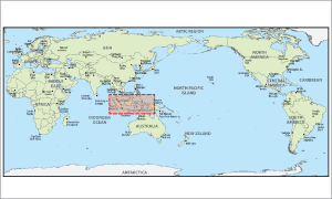 |
Coverage :
Indonesia, Malaysia, Singapore |
|
Information :
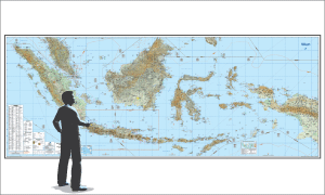
Indonesia VFR Wall Planning Chart is designed for VFR preflight planning and provides aeronautical and topographic information of the conterminous Indonesia. The aeronautical information includes airports, radio aids to navigation, Class B airspace and special use airspace. The topographic information includes city tint, populated places, principal roads, drainage patterns and shaded relief.
Paper chart size, 532 x 207 Centimeters flat, is updated annually. Scale 1:1.000.000 |
|
Aeronautical :
- Airspace Area
- Airport Information
- Radio Navigation Aids |
Topograpichal :
- Geography Grid Coordinate
- Contour line(feet accuracy base on MSL)
- Transportation line (Road, Railroad, Across)
- Population Areas
- Drainage and Name (River, Lake)
- Spot Height (feet, accuracy base on MSL)
- MEF (Minimum Elevation Figure) |
Doc. Reference :
|
Remarks :
Indonesia, Malaysia, Singapore |
|