| NO |
CODE |
Chart Name |
Location |
Edition |
EFF Date |
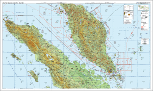
| 1. |
ONC-01 |
Operational Navigation Chart_01 |
Northern Sumatra, Malaysia, Singapore |
2024-01/038 |
25 Jan 2024 to 18 Apr 2024 |
| 2. |
ONC-02 |
Operational Navigation Chart_02 |
Southern Sumatra, (Indonesia) |
2024-01/039 |
25 Jan 2024 to 18 Apr 2024 |
| 3. |
ONC-03 |
Operational Navigation Chart_03 |
Northern Kalimantan, Malaysia, Brunei |
2024-01/039 |
25 Jan 2024 to 18 Apr 2024 |
| 4. |
ONC-04 |
Operational Navigation Chart_04 |
Southern Kalimantan, (Indonesia) |
2024-01/038 |
25 Jan 2024 to 18 Apr 2024 |
| 5. |
ONC-05 |
Operational Navigation Chart_05 |
Java and Bali, (Indonesia) |
2024-01/038 |
25 Jan 2024 to 18 Apr 2024 |
| 6. |
ONC-06 |
Operational Navigation Chart_06 |
Sulawesi, (Indonesia) |
2024-01/040 |
25 Jan 2024 to 18 Apr 2024 |
| 7. |
ONC-07 |
Operational Navigation Chart_07 |
Maluku and Halmahera (Indonesia) |
2024-01/035 |
25 Jan 2024 to 18 Apr 2024 |
| 8. |
ONC-08 |
Operational Navigation Chart_08 |
Nusa Tenggara Barat and Nusa Tenggara Timur, Timor Leste |
2024-01/041 |
25 Jan 2024 to 18 Apr 2024 |
| 9. |
ONC-09 |
Operational Navigation Chart_09 |
Western Papua (Sorong, Manokwari, Kaimana) |
2024-01/037 |
25 Jan 2024 to 18 Apr 2024 |
| 10. |
ONC-10 |
Operational Navigation Chart_10 |
Eastern Papua (Wamena, Jayapura, Merauke) |
2024-01/039 |
25 Jan 2024 to 18 Apr 2024 |
.jpg)