INDOAVIS VFR Chart Series Scale 1:500.000
Sectional Aeronautical Chart (SAC)

Scale 1:500.000/Cm = 2.70Nm/Inch = 6.86

Paper Size : 100 x 47 Cm

Edition : 2012

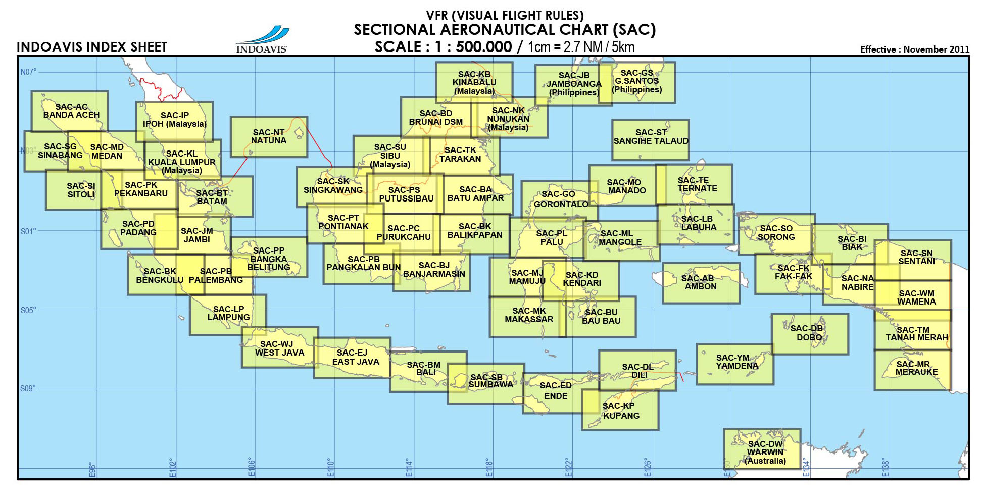
Coverage Areas : Indonesia, Malaysia, Singapore, Brunei Darussalam, Timor Leste and Australia.


AERONAUTICAL DATA SOURCE

  • AIP (Aeronautical Information Publication)

  • FLIPS (Flight Information Publication)

  • NOTAM, AIP Supplement and AIP Amendments 

TOPOGRAPHY DATA SOURCE

  • SRTM (Shuttle Radar Topography Mission) NASA

  • DCW (Digital Chart of the Word) NASA

  • RBI (Rupa Bumi Indonesia) Bakosurtanal/BIG / NKRI

  • Basic background political map is from digital chart of the world and Batas 

CATALOG AND BROCURE

  • SAC-BROCHURE...... PDF

  • SAC-CATALOGUE......PDF

  • INFORMATION CONTENT
    Sectional Aeronautical Charts are the primary navigational reference medium. The 1:500,000 scale Sectional Aeronautical Chart Series is designed for visual navigation of slow to medium speed aircraft. The topographic information featured consists of the relief and a judicious selection of visual checkpoints used for flight under visual flight rules.

    An aeronautical chart is a map designed to assist in navigation of aircraft, much as nautical charts do for watercraft, or a roadmap for drivers. Using these charts and other tools, pilots are able to determine their position, safe altitude, best route to a designation, navigation aids along the way, alternative landing areas in case of an in-flight emergency, and other useful information such as radio frequencies and airspace boundaries. There are charts for all land masses on Earth, and long-distance charts for trans-oceanic travel.
    Special charts are used for each phase of a flight and may vary from a map of a particular airport facility to an overview of the instrument routes covering an entire continent (e.g., global navigation charts), and many types in between


Index Sheet
Chart Sample (SAC-SM)

List Chart Indonesia, Malaysia, Brunai and Australia Coverage

No CODE CITY ISLAND   No CODE CITY ISLAND
1 SAC-AC ACEH Sumatera   31 SAC-MO MANADO Sulawesi
2 SAC-AB AMBON Maluku   32 SAC-ML MANGOLE North Maluku
3 SAC-BM BALI/MATARAM Bali, NTB   33 SAC-MD MEDAN North Sumatera
4 SAC-BK BALIKPAPAN Kalimantan   34 SAC-MR MERAUKE Papua
5 SAC-BJ BANJARMASIN Kalimantan   35 SAC-NA NABIRE Papua
6 SAC-BT BATAM/SINGAPORE Batam   36 SAC-NT NATUNA Riau Island
7 SAC-BA BATU AMPAR Kalimantan   37 SAC-NK NUNUKAN Kalimantan
8 SAC-BU BAU-BAU Sulawesi   38 SAC-PD PADANG Sumatera
9 SAC-BK BENGKULU Sumatera   39 SAC-PB PALEMBAN Sumatera
10 SAC-BI BIAK Papua   40 SAC-PT PALU Sulawesi
11 SAC-BD BRUNEI DSM Kalimantan   41 SAC-PP PANGKAL PINANG Bangka
12 SAC-DW DARWIN Darwin   42 SAC-PK PEKANBARU Sumatera
13 SAC-DL DILI Dili   43 SAC-PB PKL.BUN Kalimantan
14 SAC-DB DOBO Maluku   44 SAC-PT PONTIANAK Kalimantan
15 SAC-EJ EAST JAVA Java   45 SAC-PC PURUKCAHU Kalimantan
16 SAC-ED ENDE NTT   46 SAC-PS PUTTUSSIBAU Kalimantan
17 SAC-FK FAK FAK Papua   47 SAC-SN SENTANI Papua
18 SAC-GS G.SANTOS General Santos   48 SAC-ST SANGIHE TALAUT North Sulawesi
19 SAC-GO GORONTALO Sulawesi   49 SAC-SU SIBU Malaya Peninsula
20 SAC-IP IPOH Malaya Peninsula   50 SAC-SB SINABANG Sumatera
21 SAC-JM JAMBI Sumatera   51 SAC-SK SINGKAWANG Kalimantan
22 SAC-JB JAMBOANGA Jamboanga   52 SAC-SI SITOLI Sumatera
23 SAC-KD KENDARI Sulawesi   53 SAC-SO SORONG Papua
24 SAC-KB KINABALU Kalimantan   54 SAC-SB SUMBAWA NTB
25 SAC-KL KUALA LUMPUR Malaya Peninsula   55 SAC-TM TANAH MERAH Papua
26 SAC-KP KUPANG NTT   56 SAC-TK TARAKAN North Kalimantan
27 SAC-LB LABUHA North Maluku   57 SAC-TE TERNATE North Maluku
28 SAC-LP LAMPUNG Sumatera   58 SAC-YM YAMDENA Maluku
29 SAC-MK MAKASSAR East Sulawesi   59 SAC-WM WAMENA Papua
30 SAC-MJ MAMUJU West Sulawesi   60 SAC-WJ WEST JAVA Java

Copyright © 1999-2012; Indoavis Nusantara Inc. All Rights Reserved.