.jpg)
INDOAVIS VFR Chart Series
World
Aeronautical Chart (WAC) - ICAO
| Chart Name | World Aeronautical Chart-ICAO |
| Produced by | PT.INDOAVIS NUSANTARA |
| Published by | DGCA (Directorate General of Civil Aviation) Republic of Indonesia |
| Chart Scale | 1:1.000.000 /5.4Nm |
| Edition | 2012-2013 |
| Coverage Areas | Indonesia and Surrounding Countries |
| Chart paper size | 66 x 44 Cm |
| Aeronautical Data Source | 1) AIP (Aeronautical Information Publication) |
| 2) NOTAM, AIP Supplement and AIP Amendments | |
| Topography Data Source | 1) SRTM (Shuttle Radar Topography Mission) NASA |
| 2) DCW (Digital Chart of the Word) NASA | |
| 3) RBI (Rupa Bumi Indonesia) BIG | |
| 4) Peta NKRI Edition 17 Augustus 2012 BIG | |
| Function | This chart shall provide information to satisfy the requirements of visual air navigation. This chart may also serve: 1) as a basic aeronautical chart: - a) when highly specialized charts lacking visual information do not provide essential data; - b) to provide complete world coverage at a constant scale with a uniform presentation of planimetric data; - c) in the production of other charts required by international civil aviation; 2) as a pre-flight planning chart. |
| Availability |
The World Aeronautical Chart — ICAO 1:1 000 000 shall be made available in the manner prescribed in 1.3.2 for all areas delineated in Appendix 5. Note.— When operational or chart production considerations indicate that operational requirements can be effectively satisfied by Aeronautical Charts — ICAO 1:500 000 or Aeronautical Navigation Charts — ICAO Small Scale, either of these charts may be made available instead of the basic 1:1 000 000 chart. Recommendation.— To ensure complete coverage of all land areas and adequate continuity in any one coordinated series, the selection of a scale of other than 1:1 000 000 should be determined by regional agreement. |
|
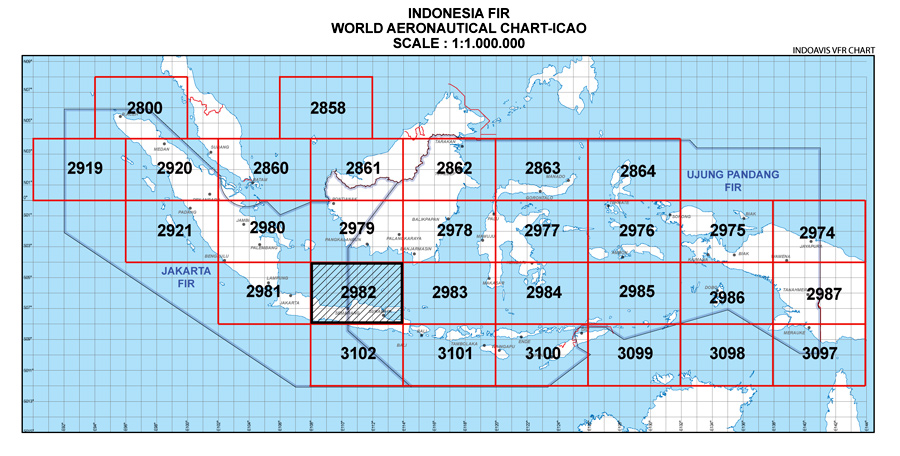
Index Sheet |
|
Chart Sample (WAC-2982) |
NOTE : Not for sales, the goverment project.
Copyright © 1999-2014; Indoavis Nusantara Inc. All Rights Reserved.