 |
Qatar Civil Aviation Authority
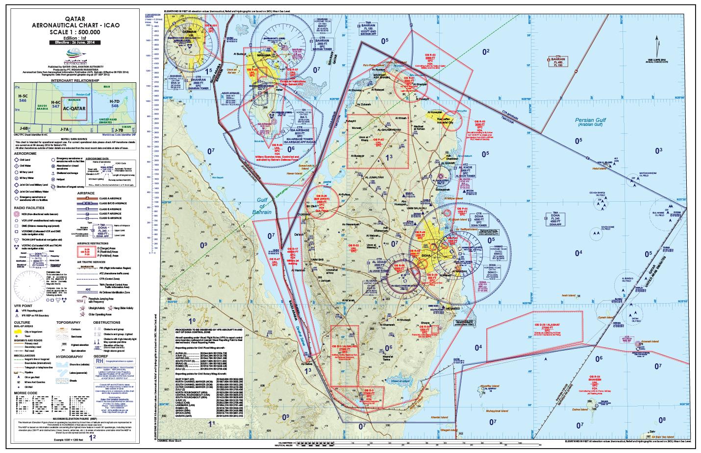
Aeronautical Chart (AC) - ICAO
Effective : 26 June, 2014
Published by QATAR CIVIL AVIATION AUTHORITY
Produced by PT. INDOAVIS NUSANTARA
Aeronautical Data from Aeronautical Information Publication (AIP), Bahrain (Effective 06 FEB 2014)
Topographic Data from geoportal.gisqatar.org.qa (07 SEP 2012) |
INTRODUCTION
PT
INDOAVIS NUSANTARA, as an Indonesian National Company, has for 15 (fifteen)
years, experience in Geo Informatics and Aeronautical Navigation Support, and
has proven it is ability and proven in the ability to serve the needs of the
Nation. Since 1998 Indoavis has produced various Aeronautical Product and
services, among others, the need of VFR Chart (the ONC and SAC), which
previously the Indonesian Aviation Industry, has been heavily relying on US DOD
VFR Charts.
In
2004, Indoavis has been requested by the Indonesia government (DGCA) to create
the AIP (Aeronautical Information Publication) 7th Edition of Indonesia. The
Indonesian Airforce has been supplied with FLIP (Flight Information
Publication), off all military airport by Indoavis.
Oil
company operating in Indonesia requested to provide Helicopter procedure for the
landing procedure scale 1:125.000.
Also
been entrusted by German Lido Lufthansa to supply GIS on all Airport World wide,
The Indoavis Product and services has served Indonesia and surrounding
countries, be it the Government, Private and Oil Companies.
The
Qatar AIS, has request Indoavis of the possibility to Generate The Qatar
Aeronautical Chart-ICAO 1:500.000, and we are very pleased to attend to the
request. For further details, please visit our website http://www.indoavis.co.id.
RESPONSIBILITY
The authority responsible for the production of aeronautical charts is the Qatar Civil Aviation Authority.
Aeronautical charts have been prepared in accordance with the standards and recommended practices of ICAO (Annex 4) Chapter 17 – Aeronautical Charts, and the guidance material in the ICAO Aeronautical Charts Manual (Doc 8697 - AN/889/2).
State Responsibility
-
Copyright by : Qatar Civil Aviation Authority
-
Publication by : Qatar Civil Aviation Authority
-
Data compilers by : Indoavis Nusantara
-
Production by : Indoavis Nusantara
Function
This chart shall provide information to satisfy the requirements of visual air navigation for low speed, short- or medium-range operations at low and intermediate altitudes.
Note 1.- This chart may be used:
a) to serve as a basic aeronautical chart;
b) to provide a suitable medium for basic pilot and navigation training;
c) to supplement highly specialized charts which do not provide essential visual information;
d) in pre-flight planning.
Note 2.- It is intended that these charts be provided for land areas where charts of this scale are required for civil air operations employing visual air navigation independently or in support of other forms of air navigation.
Note 3.- Where States produce charts of this series covering their national territories, the entire area being portrayed is usually treated on a regional basis.
AERONAUTICAL DATA
A. AIP (Aeronautical Information Publication)
AIP used by INDOAVIS in generating AC-ICAO-1: 500,000 is eAIP Bahrain web address
(http://bahrainaims.com/aisjan2014/2014-02-06-AIRAC/html/index-en-BH.html), with effective 06 FEB 2014 Issued by the State Kingdom of Bahrain
B. POINT DATA REFERENCES
Source data Aerodrome (ARP), Navigation Aids (VORDME, NDB, VORTAC) Aerodrome and Runway Elevation and dimension of data are obtained from AIP , the recorded airports are as much as 7 (Seven) Airports that is:
1.
(OBBI) BAHRAIN INTERNATIONAL (06 FEB 2014)
2.
(OBBS) BAHRAIN / ISA AIRBASE (06 FEB 2014)
3.
(OBKH) BAHRAIN / SAKHIR AIRBASE (06 FEB 2014)
4.
(OTBD) DOHA INTERNATIONAL (06 FEB 2014)
5.
(OTBK) AL KHOR (06 FEB 2014)
6.
(OTHH) HAMAD INTERNATIONAL (06 FEB 2014)
7.
(OTBH) AL-UDAID SUPP (19/2013)
Note: For airport DHAHRAN (Saudi Arabia) and Dalma (United Arab Emirates) are obtained from WAC-ICAO map sources code 2547, 2004 Bahrain scale 1:1,000,000. Navigation and maps contained in the AIP PDF files, such as: Aerodrome Index Chart, Radio Facility Index chart, Area Chart Edition 9.1.2014
C. POLYGON DATA REFERENCES
For data sources, and special use airspace, the Airspace Data are taken from ENR5.1 AIP-2 s / d 1-4, ENR 2.1 FIR, UIR, TMA, CTA edition of 6 February 2014, and for terminals acquired from the AD 2:17 Airspace ATS airspace at each respective airports.
TOPOGRAPHICAL DATA
Topographic data (Roads, shore lines, lakes, residential areas, network power voltage and political map) obtained from the QATAR GIS PORTAL, (geoportal.gisqatar.or . a ma inde .html ) with tracking on a digitized reference map of the Google Earth satellite image, by projecting the appearance of the objects were visible on satellite images.
A. ELEVATION DATA
Elevation data (contours), spot high, MEF (Minimum Elevation Figure) image and DEM (digital elevation model) is processed using the SRTM 30m Satellite Data, issued by NASA.
Data of Obstacles are retrieved from the AIP Bahrain source, page AD 2:10 Aerodrome obstacles, at any airport within a radius of each aerodrome circling the area.
SOFTWARE USE IN PRODUCTION
In the generation of the AC-ICAO Indoavis is using GIS Software and Map Design Software, whilst, as for the TSB software, we use the followings:
a. Autocad Map 2005.
b. Global Mapper v-15
c. ESRI Arcview
d. Google earth Convert KLM
e. Adobe Illustrator CS3
f. Adobe Photoshop CS3
TECHNICAL
SPECIFICATIONS
| Chart Name |
Aeronautical Chart-ICAO |
| Produced by |
PT. INDOAVIS
NUSANTARA |
| Published by |
QATAR CIVIL
AVIATION AUTHORITY |
| Chart type |
ICAO VFR CHART
(Visual Flight Rules) |
| Availability |
Recommendation. The Aeronautical Chart
- ICAO 1:500.000 should be made available in the manner prescribed in 1.3.2 for all areas delineated in Appendix 5.
Note.- The selection of this scale as an alternative to the World Aeronautical Chart
- ICAO 1:1.000.000 is covered by 16.2.1 and 16.2.2. |
| Chart Scale |
1 : 500.000
/2.7Nm |
| Edition |
2014 |
| Chart Projection |
Lambert conformal conic |
| Coverage Areas |
Qatar, Bahrain |
| Chart File type,
and size |
PDF / TIFF
File, 153,924 KB |
| Chart paper size |
75 x 50 Cm |
| Coordinate
Reference |
Geographical (latitude/longitude) & World Geographic Reference System
(WGS 84) |
| Elevation |
in Feet (1 Feet :
0.305 Meters) |
| MEF (Elevation
Figure) |
Maximum Elevation Figure) Based on information available concerning the highest known features in each quadrangle, including terrain and obstruction (trees, towers, antennas, etc) |
| Magnetic
Declination |
Magnetic variation, 2012 is Approximately 2.2°E easterly over the entire chart |
| Reference
Documents |
ICAO-ANNEX 2 (Rules of the Air) |
| ICAO-ANNEX 4 (Aeronautical Chart) |
| ICAO-ANNEX 5 (Units of Measurement to be Used in Air Ground Operations) |
| ICAO-Doc.8697 (Aeronautical Chart Manual) |
| ICAO-Doc.9674 (World Geodetic System) |
| Period
Aeronautical data |
When a significant change occurs but not more revisions offer than 62 Days |
| Aeronautical
Data Source |
1) Bahrain e-AIP (Aeronautical Information Publication) |
| 2) NOTAM, AIP Supplement and AIP Amendments |
| Topography
Data Source |
1) SRTM (Shuttle Radar Topography Mission) NASA |
| 2) DCW (Digital Chart of the Word) NASA |
| 3) QATAR GIS GEOPORTAL |
Request
please contact State of Qatar Aeronautical information Services (AIS).
Contact
Details:
Qatar Civil aviation authority
Aeronautical
Information Service
Head of Aeronautical Information Services
P.O.Box 73, Doha, Qatar.
Phone : +974 44656558 /221
Fax : +974 44656554
email : doha.ais@qcaa.gov.ga
Web: http://www.caa.gov.qa |
 |
Proposal AC-QATAR.pdf
Comments & Correction AC-QATAR.pdf
Copyright © 1999-2014; Indoavis Nusantara Inc. All Rights Reserved.