UNDERSTANDING OF MEF
Maximum
elevation figure or MEF
is the a type of VFR
altitude which indicates the height of the highest feature within a quadrangle
area. It is of interest to pilots, who want to be aware of the highest
mountain peaks and tall towers nearby, so that they can fly above them to
avoid controlled
flight into terrain.
MEF
information is required for
the entire soil mass/terrain,
trees, towers and
open water areas that
contain man-made obstacles (such
as gas/oil rigs and
large buildings). In a
VFR context, this altitude is commonly referred to as a "quadrantal
altitude"
MEF
CRITERIA
MEF
featuring the highest elevation,
natural or man-made,
in a rectangle bounded
by lines specifically
marked (latitude and
longitude) of a
network of fine lines and
should be centralized in
each quadrilateral described.
MEF
figures shall
be composed of the thousand feet digit (s) and a smaller hundred
foot digit. Zero thousands shall be shown with a larger thousand foot
digit of zero followed by the smaller hundred foot digit. Zero hundreds
shall be shown with a smaller hundred foot digit of zero. The last two
digits of the number shall be omitted.
METHODS
OF COMPUTATION
In
determining the MEF, extreme care should be exercised to increase
such figures only to the point where it is assured that they represent a
safe flying altitude based on the existing elevation data shown on the
source data/material.
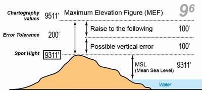
MEF Value is determined by taking the highest elevation point in the quadrangle or Spot Height, by adding 100 feet for vertical error, then added another 100 feet of the risk of error.
Round
the resultant sum to the next higher hundred foot level for the final
figure. (A resultant figure shall not be rounded up to the next higher
hundred foot level when it is an even multiple of 100).
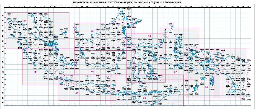
MOUNTAINOUS AREA IN INDONESIA
Based on Sheet Indoavis ONC scale 1:1.000.000
-
North Sumatra (Indonesia), Malaysia and Singapore
-
East Sumatra, West Java
-
North Kalimantan (Indonesia), Brunei Darussalam and Malaysia
-
South Kalimantan (Indonesia)
-
Java and Bali (Indonesia)
-
Sulawesi (Indonesia)
-
Maluku and Halmareha (Indonesia)
-
Nusa Tenggara Timor-Kupang, Timor Leste
-
West Papua (Sorong, Manokwari, Kaimana)
-
East Papua (Wamena, Jayapura, Merauke)
EXAMPLE CHART
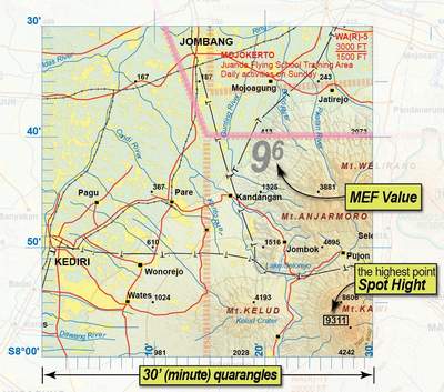
Examples of Indoavis SAC Scale 1:500.000 map in one quadrant of latitude longitude coordinates of lines per 30 Minutes
METHODS CALCULATION